Satellite data show construction work may be tied to Tokyo sinkhole
Ground levels sank after tunnel-boring machine passed under residential area
Nikkei staff writers
TOKYO -- The October 2020 cave-in of a section of road in a residential part of Tokyo may have been linked to underground construction work, according to a Nikkei analysis of satellite data.
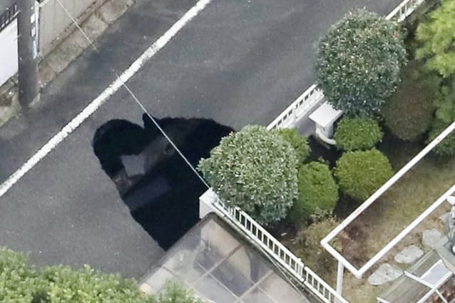
On Oct. 18, Tokyo residents reported a sinkhole roughly five meters wide, three meters long and five meters deep. Ground levels around the collapse site had warped by between two to three centimeters soon after a tunnel-boring machine passed under the area on Sept. 14. The machine was drilling an underground tunnel as a part of the Tokyo Outer Ring Road construction project.
The tunnel construction work was occurring at a depth of 40 meters, which is classified as “deep underground” in Japan. Deep underground space is not usually used by homeowners living above it, and businesses that serve a public interest, such as road and railway operators, can use this space without homeowners’ consent if they obtain approval from the Ministry of Land, Infrastructure, Transport and Tourism (MLIT) or prefectural government authorities.
Nikkei’s analysis showed that the ground surface had also moved in areas other than that directly above the tunnel construction site. A causal link between the warping ground levels and the construction remains unconfirmed pending a full investigation by authorities.
A month before the sinkhole was discovered, a boring machine 16 meters in diameter -- equivalent to a five-story building -- passed underground at a depth of 47 meters.
Nikkei analyzed the movements of the ground surface there and in surrounding areas using a technology called “interferometric synthetic aperture radar,” or “InSAR.” The technology uses satellites and radio waves to enable observers to note changes in the ground surface.
Nikkei obtained data from Italian satellite data analysis company Tre Altamira and Japan’s Space Shift and examined how the surface changed in an area around the sinkhole that measured 530 meters east to west, and 870 meters north to south.
As of April 8, 2020, before the tunnel work began, there were only two spots where the surface rose by one centimeter or more. But changes started to appear rapidly as of Sept. 20, less than a week after the boring machine passed directly below the sinkhole site. There were many spots where the surface rose or sank by one centimeter or more. By Oct. 12, shortly before the collapse, some spots had sunk by about three centimeters.
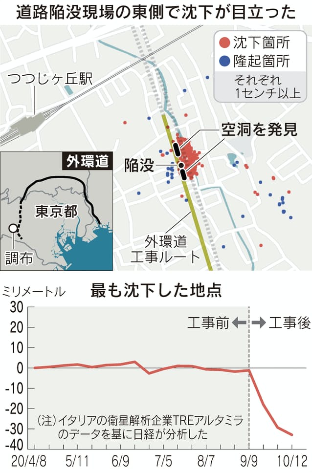
Nikkei’s analysis also showed the ground level dropped noticeably on the east side of the cave-in site and rose on the west side. There were widespread changes in places other than those directly above the tunnel work, with many locations on the opposite side of a nearby river shifting one centimeter or more.
Many of the spots that shifted rapidly from mid-September had barely moved between April and August.
Nikkei worked with Jiro Takemura, an associate professor at the Tokyo Institute of Technology, to confirm that some utility poles were slanted, cracks were appearing on houses and manhole covers were coming off. These things are often seen in places where the ground surface changes, according to Takemura. Multiple residents said they had not observed such changes before the tunnel work took place.
Authorities at MLIT and two expressway operators -- East Nippon Expressway Co. and Central Nippon Express Co. -- had previously offered assurances that construction activities would be safe. Ministry officials and the two companies had said “any phenomenon undermining safety on the ground surface” would not happen as sufficient safety measures were taken.
On Nov. 4, after the collapse, East Nippon Expressway announced it had discovered an underground cavern above the tunnel site, five meters below the surface. The space was 30 meters long, four meters wide and three meters high. On Nov. 22 the company said it had found another cavern in a different location. This cavity was 27 meters long, three meters wide and four meters high, and located four meters below the surface. There are believed to be roads and houses above the cavern.
Some residents have noticed changes in the area. In one area where the ground sank, a man complained about gaps and cracks that appeared on concrete walls, and noted that manholes seemed to be rising.
A woman in her thirties said that “thuds” began pounding throughout her house in mid-September. “I thought someone in the area was playing music at full volume,” she said. “I didn’t realize that it was because of the [tunnel] construction work at first.”
MLIT and the two expressway operators have established a panel of experts to investigate the cave-in. The group is headed by Atsushi Koizumi, a professor emeritus at Waseda University. After reviewing Nikkei’s analysis, some members of the panel and other senior officials at MLIT acknowledged that the ground surface sank by about two centimeters near the site of the collapse.
The panel is still gathering information, including through a boring survey, without using InSAR satellite data. The technology is thought to be unable to capture widespread movements in the ground surface and minor changes over time.
The group of experts presented some of its findings on Dec. 18. According to a person with knowledge of the matter, some members of the panel believe that vibrations caused by the tunnel work had some impact on the cave-in. Some civil engineering experts believe that vibrations led sand in the area to condense, which caused the ground to sink.
“If we could pin down the cause, we will be able to take necessary measures, including ground improvement,” a person familiar with the panel said. “That will enable us to do the excavating work more safely and resume construction in areas that have no problems.”
Compensation for residents of the area will be considered if a clearer causal relationship between the construction and the damage is discovered.
A spokesperson for East Nippon Expressway’s Kanto Branch declined to comment, saying that the cause of the collapse has yet to be determined.
A law governing the use of underground space in Japan’s three metropolitan areas, which include Tokyo, Osaka and Nagoya, came into effect in 2001.
Using deep underground space for roads and railways enables planners to shorten routes and cut costs. The use of deep underground space has been approved for four projects in Japan, including the Tokyo-Nagoya section of the Linear Chuo Shinkansen project.